On August 14, 2021, rain fell for several hours at the highest point on the Greenland Ice Sheet, accompanied by air temperatures that stayed above freezing for approximately nine hours. This marked the third such event in less than a decade and was the latest in the year on record that the National Science Foundation’s Summit Station experienced above-freezing temperatures and wet snow. Notably, there are no prior reports of rainfall at this location (72.58°N 38.46°W), which sits at an elevation of 3,216 meters (10,551 feet).
Previous melt events recorded in the instrumental era occurred in 1995, 2012, and 2019. Before these, ice core data suggest that such melting had been absent since the late 1800s. The melting event from August 14 to 16, 2021, was driven by weather patterns similar to those observed in late July of the same year. A strong low-pressure system over Baffin Island, combined with high-pressure conditions southeast of Greenland, created a pathway for warm, moisture-laden air to flow northward, triggering the event rapidly.
Conditions
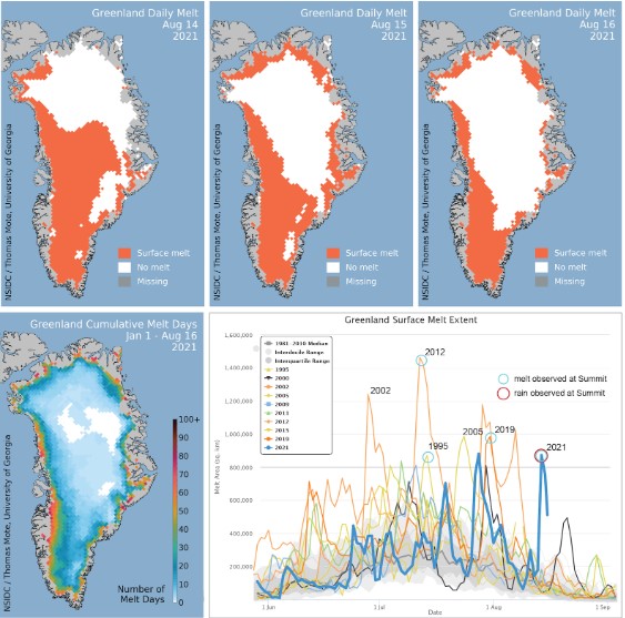
On August 14 and 15, widespread surface melting and a significant rainfall event occurred along Greenland’s southeast coast, extending to the Summit region. By August 16, the melt area returned to moderate levels (Figure 1a). Melt extent peaked at 872,000 square kilometers (337,000 square miles) on August 14, decreasing to 754,000 square kilometers on August 15 and 512,000 square kilometers (198,000 square miles) on August 16. Only the years 2012 and 2021 have experienced more than one melt event exceeding 800,000 square kilometers (309,000 square miles), and the August 14 event represents the latest date for such an extensive melt in the satellite record.

Image credit: NSIDC
At Summit Station, temperatures rose above freezing around 07:00 UTC (5:00 AM local time) on August 14, coinciding with the start of the rain event (Figure 1b). For several hours, rain fell, and water droplets were observed on surfaces near the camp, as reported by on-site observers. By 14:00 UTC, thin ice sheets began to form on the snow surface as the rain froze into the snowpack. Winds reached 9.8 meters per second (22 miles per hour) from the southwest, with a mix of freezing and non-freezing rain. Temperatures peaked at 0.48°C (33°F) around 10:40 UTC before falling below freezing at approximately 16:20 UTC. As skies cleared later in the evening, temperatures sharply dropped to -8.5°C (16.7°F) by early August 15 (Figure 2). Summit Station temperatures did not reach the melting point on August 15 or 16.
The total surface melt extent for 2021 through August 16 reached 21.3 million square kilometers (8.2 million square miles), tied for the fourteenth highest on record and significantly above the 1981-2010 average of 18.6 million square kilometers (7.2 million square miles).
Conditions in context
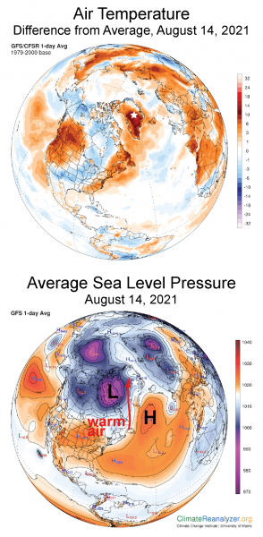
A weather pattern similar to the extensive melt events of late July 2021 (as detailed in a previous post) was responsible for the significant melt and rain event in mid-August 2021. A moderately strong low-pressure system (987 millibars at its center) moved northeast across Hudson Bay toward Baffin Island (Figure 2a). Simultaneously, high-pressure conditions off southern Greenland in the Denmark Strait created a strong pressure gradient over the southern Labrador Sea and Baffin Bay. This gradient drove powerful winds from the south-southwest, carrying warm, moist air northeastward onto Greenland’s southwestern coast. Over the following days, this warm air spread across the island. By August 15, clearing skies allowed much of the north-central ice sheet to cool significantly.

Image credit: NSIDC
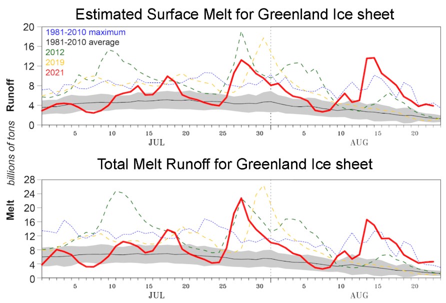
The combination of warm conditions and the late-season timing of the three-day event, coupled with rainfall, resulted in both high melting and significant runoff into the ocean. According to data from MARv3.12, this was the largest rainfall event recorded since 1950, based on ERA-5 data (Figure 2b). Notably, melt volume calculations do not include the additional water from rainfall during the warm air intrusion, except in runoff areas where the surface is icy and impermeable. Across most of the ice sheet, meltwater or rainfall typically percolates into remaining snow and refreezes. However, in regions of bare ice or water-saturated snow near the coast, meltwater and rainfall runoff occur, leading to mass loss from the ice sheet.

Image credit: NSIDC
On August 15, 2021, the surface mass loss was calculated to be seven times the mid-August average, based on MARv3.12. At this stage of the season, large areas of bare ice along Greenland’s southwestern and northern coasts lack the capacity to absorb meltwater or rainfall. Consequently, the accumulated water on the surface flows downhill, eventually draining into the ocean.
Rain check

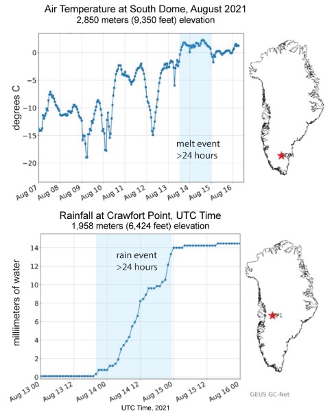
Image credit: NSIDC
During the three-day period, above-freezing temperatures and rainfall were widespread across southern and western Greenland, with exceptional measurements recorded at several remote weather stations in the region. A total of 7 billion tons of rain fell on the ice sheet. At South Dome, the highest point on the southern lobe of the ice sheet at an elevation of 2,850 meters (9,350 feet), satellite data confirmed melting throughout all three days of the warm event. Early in this period, particularly on August 14 and 15, rapid warming and sustained above-freezing temperatures were observed (Figure 3).
References
- Fettweis, X., M. Tedesco, M. Broeke, J., and Ettema. (2011). Melting trends over the Greenland ice sheet (1958–2009) from spaceborne microwave data and regional climate models. The Cryosphere, 5(2), 359-375. https://doi.org/10.5194/tc-5-359-2011
- Nghiem, S. V., D. K. Hall, T. L. Mote, M. Tedesco, M. R. Albert, K. Keegan, C. A. Shuman, N. E. DiGirolamo, and G. Neumann. (2012). The extreme melt across the Greenland ice sheet in 2012. Geophysical Research Letters, 39(20). https://doi.org/10.1029/2012GL053611
- The Geological Survey of Denmark and Greenland (GEUS) continues to operate the Greenland Climate Network (GC-Net), a program initiated in 1995 by Konrad Steffen of the Cooperative Institute for Research in Environmental Sciences (CIRES) at the University of Colorado Boulder.